SV Prism has sailed over 35,000 nautical miles since 2013—up and down the Pacific Coast, through refit seasons, across the U.S., and into multiple cruising grounds. Her historic GPS tracks are preserved here for anyone who enjoys route planning, studying passages, or understanding Prism’s earlier chapters.
Prism’s History
Prism’s early voyages carried her from Washington down the Pacific Coast, through Mexico, across the U.S., and into the East Coast. Those historic tracks remain part of her legacy and continue to inspire both our own planning and fellow sailors.
Where We Are Headed
Prism is entering a new era shaped by seamanship, family planning, fieldwork, and documentary storytelling. Our future routes reflect both adventure and purpose—and are flexible by design.
Crossing the Atlantic to Europe
A long-held dream: sailing Prism across the Atlantic.
The plan to make an Atlantic crossing toward Europe and spend extended time exploring European coasts, waterways, and cultures—while filming long-form documentary projects tied to water, climate, and the human experience at sea.
Our Evolving Route Map
SV Prism and Jon started in Washington 2013 and now 9,283 nautical miles later in 2017 we are on the east Coast of the US. Jon and I have uploaded our tracks so you can use them for a reference . If you would like them, you can Download Prism’s GPS Tracks
by clicking the link.^^
The files can be input into your Chart-plotter devices for reference only. The tracks are not to be used for navigation. They are compatible with most charting systems.
We have the dream to getting to Europe some day on Prism, how to get there is an ever-changing plan, there are just so many options to get there! But for now, we think this is the route Prism is going to take……. posted as the plan changes:
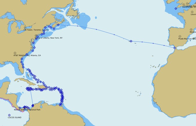
This is the “As of November 2016 Plan”
